|
|
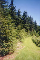
Cranberry Wilderness Area |
|

|
|
Cranberry Wilderness Area |
|
About the Wilderness
Cranberry Wilderness is the largest USFS Wilderness east of the Mississippi. This 35,864 acre Wilderness is
bounded on the west by an additional 26,000 acres known as the Cranberry Backcountry. On the east, the Wilderness
is bounded by the Highlands Scenic Highway - once envisioned as being an extended highway crossing the high mountains
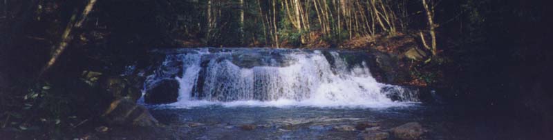
of the Allegheny backbone of West Virginia. Two scenic rivers pass through the area - the Williams River (and more
specifically, the middle fork of the Williams River which originates in the Wilderness) and the Cranberry. The
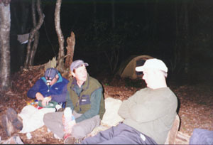
latter is a favorite fishing local for hundreds of fishermen. Seven three-sided Adirondak shelters are located
along the Cranberry River and are available on a first come, first served basis. On any given weekend of the year,
they are heavily used.
One of the most unusual features in the region is the Cranberry Glades Botanical Area, a 750 acre bog located at
the southern tip of the Wilderness - the largest in West Virginia. Bogs are acidic wetlands more commonly found
in the northern areas of this country and in Canada. The ground in a bog is spongy and consists largely of partially
decayed plant material known as peat. Because of its unique conditions, some unusual plants grown in bogs, including
carnivorous or insect-eating plants. These plants and others were pushed south when glaciers covered the northern
hemisphere. When the glaciers retreated, the bog became an island ecosystem and the southern- most point in North
America where some of these life forms are found. A half-mile boardwalk trail leads you into this unique area,
and guided tours are also available from the Cranberry Visitor Center located just to the south.
The entire back country, like virtually all of the East Coast of the United States, was clear-cut by timber companies
at the turn of the century. The entire area, as is typical of most of the mountainous regions of West Virginia,
is criss-crossed with old railroad grades. In the 1970's, large coal deposits were identified, and for a while,
it seemed that Cranberry might become West Virginia's largest strip mine. Fortunately, in the 1980's a portion
of the backcountry was set aside as a Federally-designated Wilderness which brought protection from man-made intrusions.
However, with the good came the bad. The Federal designation brought many new visitors to the area to enjoy this
unique area, and it's not as secluded as it once used to be.
Weather and Snow
Visitors should be prepared for sudden weather changes. The weather in the area tends to be wet and variable.
Although summer daytime temperatures are usually in the 70's or 80's, frost can occur at any time of the year at
the higher elevations. I can attest to this after a three day trip many years ago where the temperature was 92
degrees on the first day, and 32 degrees the last evening of the trip. Mid-winter temperatures of -25 degrees or
lower are possible. The area often sees heavy snow. The temperature changes in Cranberry are unusual to say the
least.
About the area......
Cranberry is what I call the deep, DEEP woods of West Virginia. Lots of spruce and glistening mountain streams
are the hallmark of this area, as well as a feeling that you're "really out there". While the 6 hour
drive to the Wilderness may cause someone from a major city to hesitate, it is well worth the trip - WELL worth
it.
As for the Wilderness designation, I look at it with mixed emotions. I'm mighty glad the area is protected, but
I remember the times in the late 1980s when you could visit the backcountry without seeing anyone. Most people
stayed along the Cranberry river where they could haul in carts of gear via bicycle and camp out in the shelters,
spending the day fishing. Today, it is very likely that you will see people in your travels, but it's a small sacrifice
to pay considering the extraordinary mountain beauty that has been brought under Wilderness protection.
Trails worth hiking?
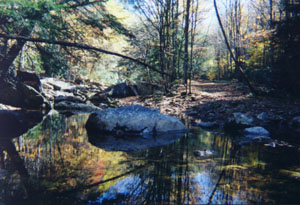
I have three that are special favorites. The Middle Fork of the Williams River is the only river in area completely
encompassed by the backcountry. The water is crystal clear, cold, and sparkling. An old railroad grade parallels
the river for close to twelve miles, finally meeting the main branch of the Williams at an area known as "Three
Forks of the Williams River". The large, flat field in this location was the site of a logging camp around
the turn of the century, and some of the building foundations can still be located. It was also the site of an
unauthorized "Rainbow gathering" in the 1980s.
The Middle Fork of the Williams passes through a beautiful, 100-year-old woods with plenty of ferns along the way.
The woods are open for the most part, except in those places where rhododendron grow in closely woven bunches.
The railroad grade is an easy, gentle walk through exceptionally pretty forest. The river alternately cascades
over boulders, or flows quietly along huge, flat slabs of stone. There are a few spots suitable for wading if one
is up to the very cold water temperatures.
My second favorite trail is the Big Beechy, which starts near the top of the Middle Fork of the Williams River
and re-enters that trail about 7 miles later. It's possible to get a lonely sense of seclusion and isolation along
the Big Beechy. The trail starts at a broad flat expanse traveling through young spruce, then heads into more mature
forest with large trees in the middle section. Then Big Beechy makes an extended, in some places steep, drop down
to the Middle Fork with restricted views into what appears to be a very wild little hollow. There's an elusive
quality about this trail that is very special, and it's difficult to adequately explain it in words.
The third trail that's a favorite is the North/South trail which follows the ridge dividing the Middle Fork of
the Williams river and the Cranberry. There are lots of Spruce along the ridge top. In some places, the rhododendron
grow close into the trail. This is deep, DEEP woods, and the rolling trail courses in and out of younger then more
mature stands of trees.
Many of the other trails in Cranberry are also special. The routes down the hollows to the Cranberry River are
very pretty. Hikers might discover some of the old railroad ties from the timbering days along these routes. The
walk along the Cranberry River isn't the best - it follows a well used, improved gravel road along the river, but
the river is big and some of the views are very nice. Don't expect the shelters to be open though. The river is
heavily visited by fisherman who often bring their families along with them. The Forks of Cranberry Trail has a
very interesting rock formation called "Elephant Rocks", offering restricted views of the backcountry.
A much better view of the backcountry is available at the Cranberry Glade Overlook along the Highlands Scenic Highway.
Cranberry Wilderness/Backcountry is a "great escape" for a three-day weekend. A stop in the Vistor Center
will help acquaint you with the natural, as well as civilized history of the region. You can contact the Visitor
Center at 304-653-4826.
Permits
Not required.
Hunting
Allowed. Backpackers/hikers traveling during this season might consider wearing blaze orange or brightly
colored clothes.
Mountain Biking
Strictly prohibited in ALL USFS Wilderness Areas. Allowed in the contiguous non-Wilderness Backcountry.
Cross-country Skiing
Suitable for semi-experienced skiers, or beginners, provided they stick to the river valleys. Winter access can
be a challenge since the Highlands Scenic Highway is gated during heavy snow and some FS roads are not regularly
plowed. However, one easy access point exists at FS 102 which leaves WV Route 55/39 and passes the western edge
of the Cranberry Glades Botanical Area into the backcountry. Skiers should be prepared for extremely cold temperatures.
Campfires
Legal, but not recommended. Please protect the Wilderness for future generations and use your backpacking
stove and either an oil or candle lantern for light when you're visiting the area. Fires can be dangerous if not
properly tended and extinguished, and they leave an ugly fire ring for the next visitor.
Also Of Interest
The book The Last Forest, by G. D. McNeill (ISBN 0-8229-5406, 1940 with second printing 1990) takes
you back in time to the 1880's, to the unspoiled Cranberry Wilderness. McNeill's collection of stories begins with
the forest primeval, before the railroads and loggers disturbed the tranquility of centuries. It ends fifty years
later, with the last virgin forest cut over and despoiled. The book also touches on stories local to the region,
and centers on the Cranberry and Williams Rivers. Formerly out of print for almost half a century, this facinating
"look back in time" can provide a real appreciation for what the Wilderness once was. (Published by McClain
Printing Co., P.O. Box 403, Parsons, WV 26287 and available for $9.95)
Click here for Trail Map of Area.........