Dolly Sods Wilderness Area
Dolly Sods is an area of high elevation wind-swept plains on the Allegheny Plateau. At elevations
of 2,600 to over 4,000 feet, the area has extensive flat rocky plains, upland bogs, beaver ponds, and sweeping
vistas. The plant life and climate on this high plateau resembles northern Canada, and many species found here
are near their southernmost range.
The 10,215 acre wilderness was designated by Congress in 1975 and is located in West Virginia's Tucker and Randolph
counties. The high plains area was once covered with 7 to 9 feet of humus. This humus layer was formed under a
red spruce/hemlock forest - a forest where the average tree was four feet in diameter. Sadly, these once stately
giants were felled during the timber rush of the late 1800's. Hot fires in the logging slash burned the area extensively
and destroyed the fertile humus layer. In the inhospitable climate and present rocky soil of Dolly Sods, red spruce
now struggle to attain 12" in diameter. (A story and pictures of this logging effort can be read in PATC's
article about What happened to the virgin forests of West Virginia.)
About the time the slash fires raged, local farmers burned the plains to create grazing land or "sods".
The pioneer Dahle family used the sods for grazing about the turn of the century. Their German name became the
present "Dolly" of Dolly Sods. The Civilian Conservation Corps planted red pine and other conifers in
the area in the 1930's and assisted with the construction of Forest Road 75, now the main access into the Wilderness
area.
In 1993, the Nature Conservancy purchased a large tract of land just north of the Wilderness Area from Quintana
Corporation, a Texas oil company. This key purchase dramatically expanded the high plains region, following in
a rough arc from Bear Church Rock to the north-western tip of the present Wilderness located near Cabin Mountain.
The property has been turned over to the USFS in two donations. It is unclear at this time whether the property
will be officially incorporated into the Dolly Sods Wilderness proper, or remain simply as additional USFS acreage.
About the Mortars......
During World War II, the Dolly Sods was used for military exercises, and some live mortar shells remain buried
in the soil. The Forest Service has currently contracted with a private firm to clear the trail corridors (500
feet on each side) of these hidden hazards. Work is expected to continue through November 1998. The shells are
definitely out there - I know one individual who found one, and also happened upon one of the bomb disposal contractors
who verified that there remain plenty to be removed. If you should happen upon an unexploded shell, DO NOT TOUCH
IT. Nitroglycerin, a component in the gunpowder charge, settles over time and can become extremely volatile. Moving
the shell may cause the mortar to explode. Mark the location, draw a map of how to find it, and contact the District
Ranger in Petersburg as soon as possible. While discovery of shells is extremely rare, they are still being discovered
on occasion by hunters and backcountry travelers.
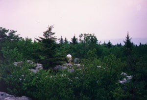
Weather and Snow
"Camp" in Dolly Sods Wilderness during a late fall snowstorm on the Breathed
Mountain Trail.
Weather on the plateau can be severe, and many of the red spruce growing in exposed areas have branches growing
on only one side of the trunk. During winter, the area experiences heavy snow, and the access roads can become
blocked very quickly, remaining impassable even to all-wheel drive vehicles (I've seen vehicles attempt it with
bravado, and turn back). No help is available for extracting vehicles according to warning signs posted at these
access points. Temperatures can also drop well below zero during the colder months of the year. During winter,
the only dependable access into the area is at Laneville. (See map). If snow is forecast for the region, visitors
SHOULD NOT park on the high plateau along FS 75. Even with moderate snow, FS 75 can become blocked by large, wind-blown
snow drifts. Snow coverage can last most of the winter months in the high plains region.
You can get a general idea of the temperatures on the Dolly Sods plateau by visiting an online weather site such
as The Weather Channel's weather.com and requesting the report for Petersburg, WV. Then simply subtract 15 degrees
to determine temperatures on the plateau. Note that Dolly Sods often has "its own" weather, and high
winds on the plateau can create wind chill temperatures that fall far below the estimated temperature.
About the area......
In one word - extraordinary. The south-eastern region of the Wilderness is primarily cove hardwood forest typical
of other mountainous regions of West Virginia. This area is characterized by deeply cut ravines filled with rhododendron
and tumbling streams. The side streams feed into the main branch of Red Creek, a beautiful mountain river. The
main branch of Red Creek, once a deeply shaded mountain river, was devastated by the famous flood of 1985 where
the remnants of hurricane Juan dumped 8 inches of rain in the mountains of West Virginia. Today, the Red Creek
valley is "open", and a short stretch of trail just south of the Big Stonecoal Trail has been relocated
to bypass a washed out portion of the railroad grade the trail originally followed out of Laneville.
The south-western and north areas of the Wilderness are characterized by hanging valleys and rolling hills, with
many open "parks" and beaver ponds. Less experienced backpackers traveling cross-country can become easily
lost if they go off trail, so caution should be exercised.
Most visitors and locals seems to collect at an area called "The Forks", a large flat area at the confluence
of north and south branches of Red Creek. Just below this area are some beautiful waterfalls and excellent swimming
holes. However during good weather holidays, the entire Wilderness is heavily visited, and it can be a challenge
locating a suitable camping area that is well away from other visitors in the backcountry.
During the fall, the changing color of leaves in the backcountry can be "electric". This is due primarily
to the warm days, and sharply colder nights that occur in the higher regions of the Sods. The area also has a surprising
variety of tree species, so there is a veritable kaleidoscope of color in the higher regions at the height of fall
color.
Trails worth hiking?
The Sods is unique in that ALL the trails are worth hiking. Each offers something special - from the beautiful
rhododendron and views of Red Creek along the Red Creek Trail, to the former beaver ponds and open plains of the
Breathed Mountain Trail. The area is worth exploring. However, for me, the high plains region offers something
special. It's the only place I've visited on the East Coast where I could almost imagine I was in Alaska.
Trails in the cove hardwood region follow old railroad grades. Trails in the high plains region follow railroad
grades in some cases, or head cross-country. Some of these cross-country routes can be rocky underfoot and difficult
to follow in the snow. Trails are marked with old ax blazes, though some blue paint blazes may still remain. It
is highly recommend that hikers take topographic maps with them when they enter the Wilderness, since in spots
the trails can be difficult to follow to the uninitiated. The crossing of Red Creek at Little Stonecoal and Big
Stonecoal Trails can be treacherous, if not dangerous, during high water. (The crossing of Red Creek on the Red
Creek Trail further upstream can be interesting too.) A "high water route" can be located at the western
end of the bridge on State Road 45 at Laneville. The high water route, informal at best, eventually hooks up with
the Little Stonecoal Trail on the west bank of Red Creek.
Hunting
Allowed. The area is heavily visited by hunters during hunting season. Backpackers/hikers
traveling during this season should wear blaze orange or brightly colored clothes.
Mountain Biking
Strictly prohibited in ALL USFS Wilderness Areas.
Cross-country Skiing
Suitable for semi-experienced skiers. The area can be accessed from ski trails entering the Wilderness from the
west at the Big Stonecoal Trail intersection with Cabin Mountain.
Campfires
Legal, but not recommended. In the late 1980's, one of the premiere backcountry camping areas was burned extensively
by visitors who did not extinguish their campfire. Many acres of red spruce forest were scorched along the upper
Big Stonecoal region, and the camping area was destroyed. Please, use your backpacking stove and either an oil
or candle lantern for light when you're visiting the area. Campfires are not appreciated or welcome. The USFS encourages
you to follow the "Leave No Trace" ethic when you visit this heavily used backcountry area.